Mar 29, 2013
Mar 23, 2013
A “Long-lasting” Job at 1F: Women 18-62 Wanted
A job opening at Fukushima Dai-ichi nuclear power plant: women accepted!
By company “Authentic” in Okuma-cho, Futaba-gun, Fukushima Prefecture
Job starts in May.
You can make money! We will let you make money! It’s a job even women can do.
This job will last a very long time.
Urgently looking for someone with physical and mental strength.
Job location is Fukushima Dai-ichi NPP (1F) with low dose radiation (10-20 μSv)/day.
Job description is clean-up activity.
Protective suits and masks to be worn.
Lodging in Iwaki-city being arranged.
Daily wage 16,000 yen (about $150) for an 8-hour day, no extra pay for danger
Actual work hours per day = about 4 hours (short hours in summer)
Wage payment will be deposited into your bank account by the end of the following month.
Car commuting is allowed, staying in Hirono-cho on your own and taking a bus from there.
No meals provided, but under negotiation now.
Job period is 5 to 10 years, or until the reactors are decommissioned.
Other decontamination jobs also available for the same wage.
Many other jobs available.
How to apply for the job:
Please e-mail your name, age, and your contact address.
Limit 100 applicants
After checking your e-mail, we will notify you as to if you are hired.
Eligibility:
No membership in yakuza or anti-social organization. We will check
into this when reviewing your application. No tattoo or missing finger.
Your own health insurance required.
Age limit: under consideration, but will most likely be between age 18 and 62.
Applicant limit: 100
We look forward to receiving your application.
Original information, as copied below, can be found here:
第一原発 女性就労可能です!
オーセンテック - 福島県 双葉郡 大熊町
5月スタートのお仕事です
稼げます! 稼がせます! 女性も就労可能な作業です
長く続くお仕事です 体力、気力がある方急募です
第一原発 (通称1F) 低線量(10 ~ 20マイクロシーベルト)/日
作業内容 片付け等の業務です
防護服着用 マスク着用
宿 いわき市 現在調整中
日給16000円 /8h作業 危険手当は付きません
実作業時間 約4時間 (夏季はまだ短時間です)
支払い 末〆翌月末 御指定銀行に振込致します
車での赴任可能 広野町で自己管理して頂きます 広野町からマイクロバスにて移動です
食事 無 現在 交渉中
作業期間は 5 ~ 10年 もしくは廃炉までとなります
その他 除染作業も有ります 単価はほぼ変わりません
案件多数有ります
応募方法
氏名 年齢 連絡先 住所 を記載の上 メールにて応募して下さい
募集枠 100名
メール確認後 此方から採用の連絡を致します
応募資格 暴力団 過去に反社会組織に属していない 書類選考時 関係各所のチェック有り
刺青 指の欠損 などもNG 保険書を保持されている方のみです
年齢制限 現在 調整中 18 ~ 62才 までの予定
募集人員100名
ご応募お待ちしております
Mar 11, 2013
The Ministry of the Environment Thyroid Survey
Thyroid survey by the Ministry of the Environment was conducted in order to find out the incidence of thyroid nodules and cysts in children in areas not affected by radiation contamination due to the Fukushima nuclear accident. The official name for the survey is “Study of presence of thyroid findings in three prefectures outside Fukushima Prefecture.” It will be referred to as the “MOE thyroid survey” hereafter.
A preliminary result for the MOE thyroid survey was presented at a press conference on March 8, 2013, which revealed a higher percentage of A2 and B assessments than Fukushima Prefecture, at 56.6% and 1.0% respectively. (In Fukushima Prefecture, the cumulative results for A2 and B assessments were 41.8% and 0.6%, respectively). The A2 assessment includes nodules 5.0 mm or smaller or cysts 20.0 mm or smaller, only requiring observation and a follow-up ultrasound in two years. The B assessment includes nodules 5.1 mm or larger and cysts 20.1 mm or larger, requiring a secondary examination including a more detailed ultrasound examination, blood test and a possible fine-needle aspiration biopsy. As of mid-February, it was reported that the result of the MOE thyroid survey was going to be available by the end of March, which is the end of this fiscal year. It was unclear why a preliminary result was reported at this time.
Study of presence of thyroid findings in three prefectures outside Fukushima Prefecture (MOE thyroid survey) A = 56.6%; B = 1.0%
Fukushima Prefecture survey
Cumulative ratio of assessment A = 41.8%; B = 0.6%.
http://fukushimavoice-eng.blogspot.com/2013/02/fukushima-thyroid-examination-part-4.html
The comparison of the two surveys was quickly publicized as a proof that the thyroid abnormalities discovered in Fukushima are not likely due to the effect of radiation, as a higher percentage of abnormalities were found outside Fukushima Prefecture.
*****
Shinichi Suzuki of Fukushima Medical University, a physician who is in charge of the thyroid examination in Fukushima, had maintained that the “high” percentage of thyroid ultrasound abnormalities in Fukushima children was because of a high sensitivity of the ultrasound equipment being used. Since there was no comparable study available in terms of mass screenings of children using thyroid ultrasound, the Japanese government decided to launch a study outside Fukushima Prefecture.
This MOE three-prefecture survey was commissioned to the Japan Association of Breast and Thyroid Sonology (JABTS), http://www.jabts.net/, on August 31, 2012, which won an open competitive bidding. At the time, it was supposed to be a control study to obtain data to compare to the Fukushima result. However, it was allegedly explained at the press conference for the preliminary result that this study was not considered a control study but rather a study to compare incidence amongst the three prefectures. This is quite strange, since they reported the total incidence of the three prefectures.
The purpose of the survey was said to relieve the anxiety of Fukushima parents who were worried about their children’s A2 assessments. Did it really accomplish that?
Unlike the Fukushima survey, the MOE thyroid survey apparently does not include children younger than 3. Also, the survey population appears to be from a fixed location such as a particular school, which might not be a general representation of the population.
The higher percentages of 56.6% and 1.0% did not come with detailed information such as the proportion of nodules vs. cysts or the size and age distributions of nodules and cysts. It is possible that there were many findings of cysts smaller than 3.0 mm, which are not considered clinically significant yet included in the A2 assessment. Moreover, the percentage of the B assessment, eligible for the secondary examination, does not mean as much as the result of the secondary examination. For instance, in fiscal year H23, 186 out of 38,114 had B assessment, 162 underwent the secondary examination, and 76 of 162 had fine-needle aspiration biopsy. Ten children were suspected of having thyroid cancer. Three of them were confirmed to have thyroid cancer and already had surgery. Seven others will undergo surgery for tissue biopsy for confirmation.
Incidentally, Japan Association of Breast and Thyroid Sonology was one of the seven organizations included in the "Diagnostic Criteria Inquiry Subcommittee of Thyroid Examination Advisory Committee." This committee decided on diagnostic criteria for thyroid ultrasound examination for the Fukushima Prefecture Health Management Survey. However,
no record could be found, at least on the Internet, regarding minutes of proceedings of this Subcommittee, revealing a potential lack of transparency.
Moreover, one of the board members of the Japan Association of Breast and Thyroid Sonology happens to be Shinichi Suzuki, who is in charge of the Fukushima thyroid examination. This could compromise the neutrality and objectivity of the MOE thyroid survey.
It is difficult to find radiation-free areas in Japan due to the nationwide incineration of disaster debris with some radiation contamination as well as the widespread distribution of contaminated foodstuff. Also, Kofu-city, Yamanashi, did get some Fukushima fallout. Rather than being content that Fukushima’s thyroid abnormalities are not much different from those other prefectures, there might be a bigger issue of why there are such high percentages of abnormalities found in children all over Japan.
We will await the full report by the Ministry of the Environment on this “comparative” study.
Mar 6, 2013
Radioactive Reed Burning
On March 17, 2013, six days after the second anniversary of the Great East Japan Earthquake and Tsunami, an annual event will resume after a two-year hiatus. It is reed burning at Watarase-yusuichi, or Watarase retarding basin, an extensive wetland that was recently registered as a Ramsar site, in July 2012, as described below.
Watarase- yusuichi
http://www.ramsar.org/cda/en/ramsar-documents-list-anno-japan/main/ramsar/1-31-218%5E16573_4000_0__
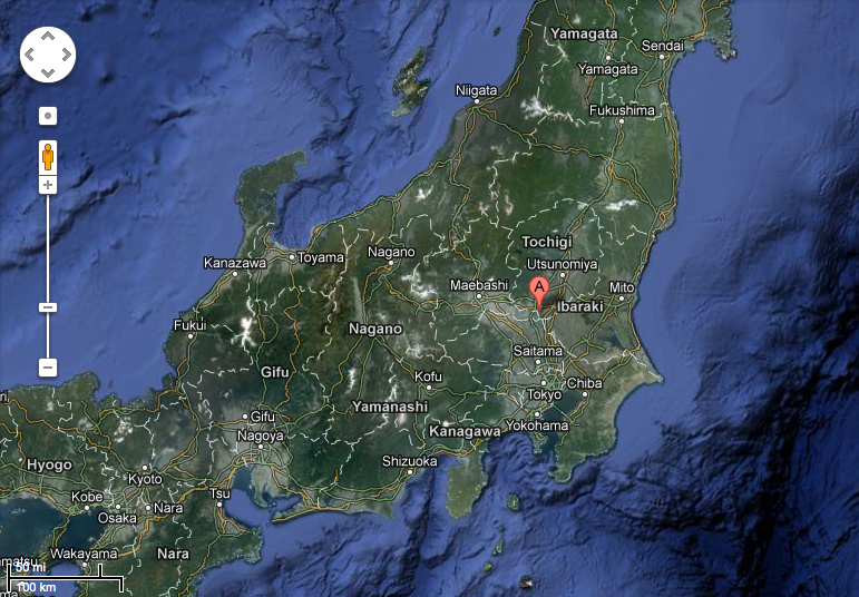
03/07/12; Ibaragi, Tochigi, Gunma, Saitama; 2,861 ha; 36°14'20"N 139°40'56"E. National Wildlife Protection Zone. A natural river flood plain where the Watarase, Uzuma and Omoi rivers meet and includes the Watarase reservoir, an artificial retarding basin surrounded by an embankment managed mainly for flood control. Located 60 km north of Tokyo, it is representative of a Phragmites australis-dominated low moor wetland in the Japanese Evergreen Forest biogeographic ecoregion. The extensive reedbed is one of the largest in the biogeographic region and supports a diversity of wetland flora and fauna. The site has an important flood control function by retarding the flood water from the rivers that flows into the site, and then slowly releasing the water into the Tone River that flows downstream. It is also used for fisheries, recreation, and environmental education. The wetland is at risk of drying up due to excess deposits of earth and sand and is being maintained through excavation since 2010. Ramsar Site no. 2061. Most recent RIS information: 2012.
Aerial view of Watarase-yusuichi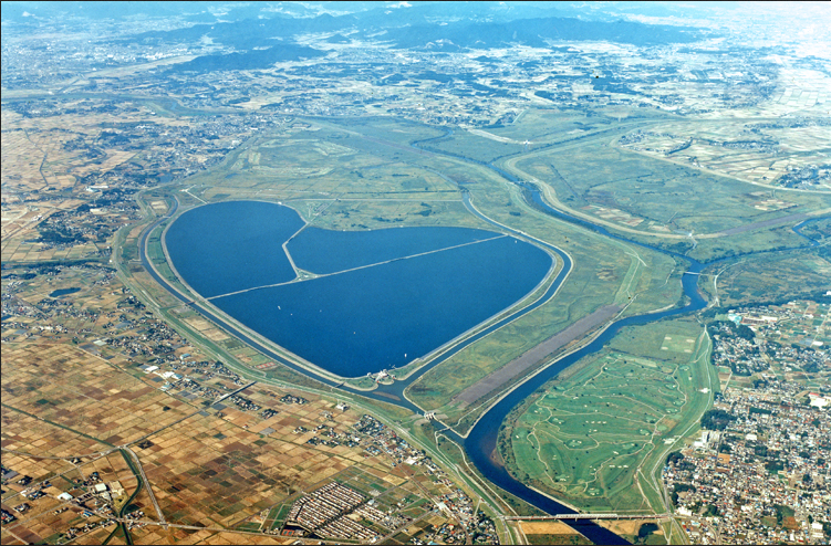


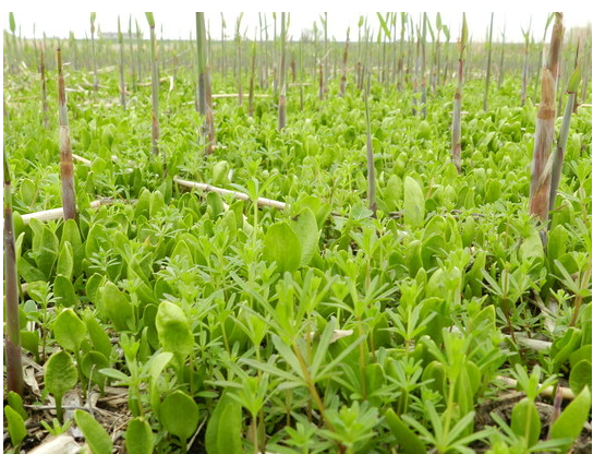
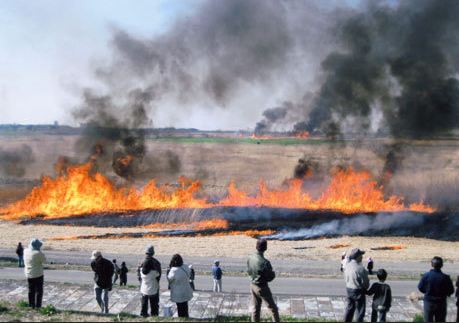
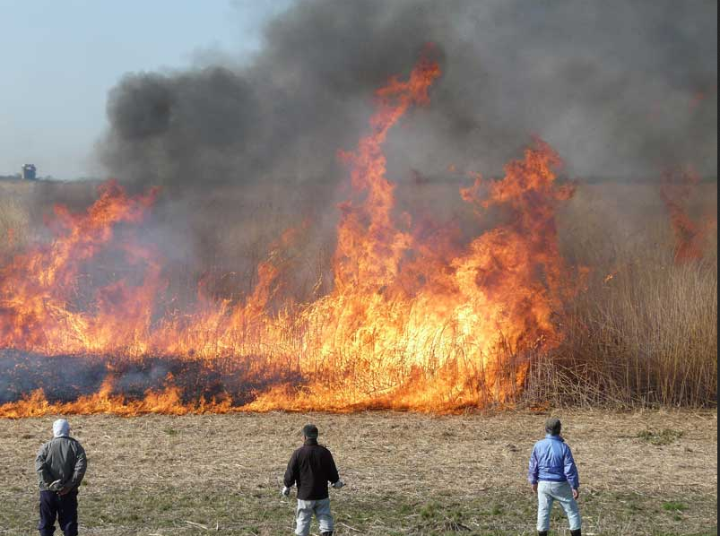
However, the wetland habitat is apparently deteriorating due to the absence of reed burning, leading to poor growth of reed and other rare plants.
Reed burning had always been sponsored by “Federation of Cooperatives Utilizing Watarase-yusuichi,” consisting of representatives from regions which utilize the retarding basin, and co-sponsored by the Liaison Committee of public workers from four cities and two towns in four prefectures, Tochigi, Saitama, Ibaraki and Gunma.
A joint committee consisting of the area local governments and the national government investigated the effect of radiation stemming from reed burning in January, checking the concentration of radioactive cesium in the incinerated ashes of reed and bottom grass. The maximum concentration was 930 Bq/kg, which was much less than 8,000 Bq/kg, the permissible limit for regular radioactive waste that can be safely disposed of in landfill. (This limit was created by the government due to the emergency situation after the accident, and it is by no means a small number). As a result, the joint committee decided on February 1, 2013, that it would be safe to resume reed burning.
As the “Federation of Cooperatives Utilizing Watarase-yusuichi” refused to take any responsibility in case something happened, it was decided that the Liaison Committee would be the sponsor. An effort will be made to the burning area small to avoid the spread of ashes and measuring ambient radiation levels before and after the fire is lit.
The general location of Watarase-yusuichi (below)
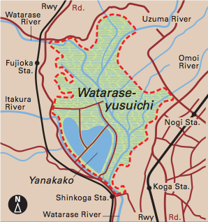
The light green area in the map below shows Watarase-yusuichi.
This site shows images of the past reed burning.
http://www.geocities.jp/nekko3rays/d_yoshiyaki.html
This video shows the 2009 reed burning.
http://www.youtube.com/watch?v=_6m9dpFHo3Q
*************************
The black smoke in the above images and the video is rather unsettling and difficult to ignore. In fact, according to the Tokyo Metropolitan Government Environmental Research Institute, field burning produces as much as 10,000μg/m3 of PM2.5 (particulate matter 2.5, which refers to very fine particles with diameter of 2.5 μm), which is of special interest in pollution as it is known to cause detrimental health effects such as respiratory illnesses.
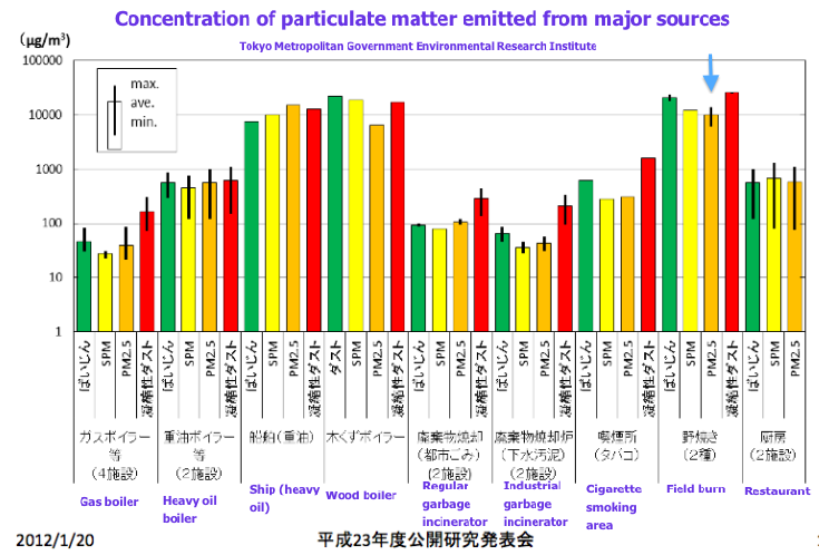
http://www.tokyokankyo.jp/kankyoken_contents/research-meeting/h23-01/2302-pp.pdf
Comparative diagram of PM2.5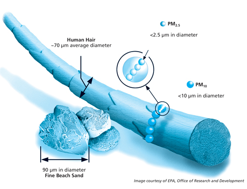
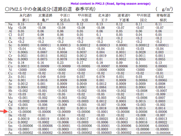
Furthermore, it has been shown that PM2.5 can contain cesium as in the table showing metal contents of PM2.5 collected by roadside in various parts of Tokyo.
http://www.kankyo.metro.tokyo.jp/air/attachement/1-1%20h20%20taikikankyoutyousa%20kekkahoukokusyo(an).pdf
To be clear, there is no testing done to identify radioactive materials in PM2.5. It is only a postulate, but this represents a large gap in data which could be used to inform the world of the dangers of burning radiation contaminated areas.
The cesium in PM2.5 in the above table has no designation as to its radioactive status. Some non-radioactive cesium does exist in nature. The amount shown in this table is very small, but it proves that cesium can exist in PM2.5.
In Chernobyl, wildfires in the contaminated areas have presented problems. In this research study, Vegetation fires, smoke emissions, and dispersion of radionuclides in the chernobyl exclusion zone http://www.treesearch.fs.fed.us/pubs/34263, an experimental grass fire revealed that nearly 45% of Cs137 was in the form of radioactive aerosols smaller than 1.8 μm, well within the PM2.5 range, as depicted by red arrows in the graph shown below.

As it has been in the news, PM2.5 levels in China are skyrocketing lately, some of which has been drifting towards Japan causing severe air pollution. In addition, it has been known that particulate matter from China reaches the United States via the world’s jetstream activity as described in the article below.
China’s Rise Creates Clouds of U.S. Pollution
http://aliciapatterson.org/stories/china%E2%80%99s-rise-creates-clouds-us-pollution
EPA’s PM2.5 site:
http://www.epa.gov/pmdesignations/
In other words, the prospective reed burning could release radioactive material into the air, some of which could be transported to other parts of the world, even in the absence of explosive forces of explosion, as PM2.5.
After the Fukushima nuclear accident, which involved 3 explosions beginning March 13, the radioactivity began to reach the west coast of the United States on March 18th.

On March 17, 2013, the proposed reed burning of the Watarase-yusuichi, has the potential to further spread radioactive materials beyond Japan's borders - affecting other nations. Alternate dates proposed, in case of rain or wet conditions, are March 20 and 24. People of the world need to realize that a strong connection between burning contaminated materials and the release of radioactive elements exists and poses a real threat to both humanity and our ecological support systems.
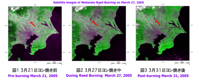
It is such a massive scale of burning that it is identifiable from above the Earth. As seen in the satellite images of the 2005 Reed Burning from the link provided below, the area of the burning can be seen at the tip of the red arrow in the middle image taken during the burning and the right image 4 days after the burning. http://www.eorc.jaxa.jp/imgdata/topics/2005/tp050401.html
Please watch the wind direction on March 17, moiitor the EPA PM2.5 monitoring site, AirNOW, for any changes, and protect yourselves from potentially radioactive dust.
Live camera covering the Watarase-yusuichi area:
Watarase-yusuichi station
http://www.ktr.mlit.go.jp/tonejo/cctv/camview.htm?cam8%3C%3E36.22805555555556%3C%3E139.65944444444446
Furukawa station
http://www.ktr.mlit.go.jp/tonejo/cctv/camview.htm?cam5%3C%3E36.192499999999995%3C%3E139.69583333333333
Otome station
http://www.ktr.mlit.go.jp/tonejo/cctv/camview.htm?cam6%3C%3E36.261944444444445%3C%3E139.74749999999997
Nakasato station
http://www.ktr.mlit.go.jp/tonejo/cctv/camview.htm?cam7%3C%3E36.2925%3C%3E139.73250000000002
Wind Map around Fukushima Daiichi Nuclear Power Plant (Google Maps Markers Version)
http://agora.ex.nii.ac.jp/earthquake/201103-eastjapan/weather/gpv/wind/marker/index.html.en
AirNOW:
http://www.airnow.gov/index.cfm?action=airnow.national&__utma=172919287.1407685150.1358728693.1361856928.1361871811.9&__utmb=172919287.4.8.1361871893696&__utmc=172919287&__utmx=-&__utmz=172919287.1361871811.9.9.utmcsr=google|utmccn=%28organic%29|utmcmd=organic|utmctr=%28not%20provided%29&__utmv=172919287.|1=visitor%20id=1407685150=1&__utmk=118164553
Of course, this reed burning is insane and terrible for local area residents’ health as well as the rest of Japan. Sadly, as we approach the second anniversary of the Fukushima nuclear accident, people’s attention is diverted from real radioactive contamination due to the intentional cover-up of this critical situation by the government and the media. Some even seem to believe everything has been cleaned up at Fukushima Daiichi nuclear power plant. Most local residents do not seem to even mention radiation in their daily conversation. Those who would care and talk about the danger of radiation contamination already moved away from areas surrounding Watarase-yusuichi. The rest of the people either believe the government telling them it’s such a miniscule amount of radiation that it won’t affect their health or they don’t care.
It is very curious that Watarase-yusuichi was designated as a Ramsar site as recently as July 2012, a little over a year after the nuclear accident. Was this coincidental? Nevertheless, it is somewhat understandable that they want to go ahead with reed burning to “keep up with the name,” so to speak, as this would be the first reed burning since the Ramsar site designation. However, it still is not logical to endanger area residents and the rest of the world.
Does the preservation of wetland habitat and endangered plant species take precedence over human health? This presents an ethical dilemma, as it speaks as to whose lives are more precious, humans or plants and wildlife. In addition, the history of Watarase-yusuichi as a retarding basin created to sink toxins derived from Ashio copper mine upstream appears to hold an emotional attachment for local people. They want to create and preserve a beautiful wildlife refugee and a central place for promoting the pride of the region which was so hurt by pollution in the past.
Sadly, now the region was polluted again. This time by radiation.
Watarase- yusuichi
http://www.ramsar.org/cda/en/ramsar-documents-list-anno-japan/main/ramsar/1-31-218%5E16573_4000_0__
03/07/12; Ibaragi, Tochigi, Gunma, Saitama; 2,861 ha; 36°14'20"N 139°40'56"E. National Wildlife Protection Zone. A natural river flood plain where the Watarase, Uzuma and Omoi rivers meet and includes the Watarase reservoir, an artificial retarding basin surrounded by an embankment managed mainly for flood control. Located 60 km north of Tokyo, it is representative of a Phragmites australis-dominated low moor wetland in the Japanese Evergreen Forest biogeographic ecoregion. The extensive reedbed is one of the largest in the biogeographic region and supports a diversity of wetland flora and fauna. The site has an important flood control function by retarding the flood water from the rivers that flows into the site, and then slowly releasing the water into the Tone River that flows downstream. It is also used for fisheries, recreation, and environmental education. The wetland is at risk of drying up due to excess deposits of earth and sand and is being maintained through excavation since 2010. Ramsar Site no. 2061. Most recent RIS information: 2012.
Aerial view of Watarase-yusuichi
Nature and wildlife at Watarase-yusuichi
Watarase reed burning, annually conducted in mid to late March, was cancelled in 2011 due to difficulties with securing firefighters to prevent burning beyond proscribed areas, after the earthquake, tsunami and nuclear disaster. In 2012, local residents opposed to it after radioactive material was detected in the ash of the bottom grass which underwent test incineration. Four prefectures abutting the Watarase-yusuichi, Tochigi, Saitama, Ibaraki and Gunma are located south of Fukushima prefecture and received consistent radioactive fallout regularly after the nuclear accident.
However, the wetland habitat is apparently deteriorating due to the absence of reed burning, leading to poor growth of reed and other rare plants.
Reed burning had always been sponsored by “Federation of Cooperatives Utilizing Watarase-yusuichi,” consisting of representatives from regions which utilize the retarding basin, and co-sponsored by the Liaison Committee of public workers from four cities and two towns in four prefectures, Tochigi, Saitama, Ibaraki and Gunma.
A joint committee consisting of the area local governments and the national government investigated the effect of radiation stemming from reed burning in January, checking the concentration of radioactive cesium in the incinerated ashes of reed and bottom grass. The maximum concentration was 930 Bq/kg, which was much less than 8,000 Bq/kg, the permissible limit for regular radioactive waste that can be safely disposed of in landfill. (This limit was created by the government due to the emergency situation after the accident, and it is by no means a small number). As a result, the joint committee decided on February 1, 2013, that it would be safe to resume reed burning.
As the “Federation of Cooperatives Utilizing Watarase-yusuichi” refused to take any responsibility in case something happened, it was decided that the Liaison Committee would be the sponsor. An effort will be made to the burning area small to avoid the spread of ashes and measuring ambient radiation levels before and after the fire is lit.
The general location of Watarase-yusuichi (below)
The light green area in the map below shows Watarase-yusuichi.
This site shows images of the past reed burning.
http://www.geocities.jp/nekko3rays/d_yoshiyaki.html
This video shows the 2009 reed burning.
http://www.youtube.com/watch?v=_6m9dpFHo3Q
*************************
The black smoke in the above images and the video is rather unsettling and difficult to ignore. In fact, according to the Tokyo Metropolitan Government Environmental Research Institute, field burning produces as much as 10,000μg/m3 of PM2.5 (particulate matter 2.5, which refers to very fine particles with diameter of 2.5 μm), which is of special interest in pollution as it is known to cause detrimental health effects such as respiratory illnesses.
http://www.tokyokankyo.jp/kankyoken_contents/research-meeting/h23-01/2302-pp.pdf
Comparative diagram of PM2.5
Furthermore, it has been shown that PM2.5 can contain cesium as in the table showing metal contents of PM2.5 collected by roadside in various parts of Tokyo.
http://www.kankyo.metro.tokyo.jp/air/attachement/1-1%20h20%20taikikankyoutyousa%20kekkahoukokusyo(an).pdf
To be clear, there is no testing done to identify radioactive materials in PM2.5. It is only a postulate, but this represents a large gap in data which could be used to inform the world of the dangers of burning radiation contaminated areas.
The cesium in PM2.5 in the above table has no designation as to its radioactive status. Some non-radioactive cesium does exist in nature. The amount shown in this table is very small, but it proves that cesium can exist in PM2.5.
In Chernobyl, wildfires in the contaminated areas have presented problems. In this research study, Vegetation fires, smoke emissions, and dispersion of radionuclides in the chernobyl exclusion zone http://www.treesearch.fs.fed.us/pubs/34263, an experimental grass fire revealed that nearly 45% of Cs137 was in the form of radioactive aerosols smaller than 1.8 μm, well within the PM2.5 range, as depicted by red arrows in the graph shown below.
As it has been in the news, PM2.5 levels in China are skyrocketing lately, some of which has been drifting towards Japan causing severe air pollution. In addition, it has been known that particulate matter from China reaches the United States via the world’s jetstream activity as described in the article below.
China’s Rise Creates Clouds of U.S. Pollution
http://aliciapatterson.org/stories/china%E2%80%99s-rise-creates-clouds-us-pollution
EPA’s PM2.5 site:
http://www.epa.gov/pmdesignations/
In other words, the prospective reed burning could release radioactive material into the air, some of which could be transported to other parts of the world, even in the absence of explosive forces of explosion, as PM2.5.
After the Fukushima nuclear accident, which involved 3 explosions beginning March 13, the radioactivity began to reach the west coast of the United States on March 18th.
On March 17, 2013, the proposed reed burning of the Watarase-yusuichi, has the potential to further spread radioactive materials beyond Japan's borders - affecting other nations. Alternate dates proposed, in case of rain or wet conditions, are March 20 and 24. People of the world need to realize that a strong connection between burning contaminated materials and the release of radioactive elements exists and poses a real threat to both humanity and our ecological support systems.
It is such a massive scale of burning that it is identifiable from above the Earth. As seen in the satellite images of the 2005 Reed Burning from the link provided below, the area of the burning can be seen at the tip of the red arrow in the middle image taken during the burning and the right image 4 days after the burning. http://www.eorc.jaxa.jp/imgdata/topics/2005/tp050401.html
Please watch the wind direction on March 17, moiitor the EPA PM2.5 monitoring site, AirNOW, for any changes, and protect yourselves from potentially radioactive dust.
Live camera covering the Watarase-yusuichi area:
Watarase-yusuichi station
http://www.ktr.mlit.go.jp/tonejo/cctv/camview.htm?cam8%3C%3E36.22805555555556%3C%3E139.65944444444446
Furukawa station
http://www.ktr.mlit.go.jp/tonejo/cctv/camview.htm?cam5%3C%3E36.192499999999995%3C%3E139.69583333333333
Otome station
http://www.ktr.mlit.go.jp/tonejo/cctv/camview.htm?cam6%3C%3E36.261944444444445%3C%3E139.74749999999997
Nakasato station
http://www.ktr.mlit.go.jp/tonejo/cctv/camview.htm?cam7%3C%3E36.2925%3C%3E139.73250000000002
Wind Map around Fukushima Daiichi Nuclear Power Plant (Google Maps Markers Version)
http://agora.ex.nii.ac.jp/earthquake/201103-eastjapan/weather/gpv/wind/marker/index.html.en
AirNOW:
http://www.airnow.gov/index.cfm?action=airnow.national&__utma=172919287.1407685150.1358728693.1361856928.1361871811.9&__utmb=172919287.4.8.1361871893696&__utmc=172919287&__utmx=-&__utmz=172919287.1361871811.9.9.utmcsr=google|utmccn=%28organic%29|utmcmd=organic|utmctr=%28not%20provided%29&__utmv=172919287.|1=visitor%20id=1407685150=1&__utmk=118164553
Of course, this reed burning is insane and terrible for local area residents’ health as well as the rest of Japan. Sadly, as we approach the second anniversary of the Fukushima nuclear accident, people’s attention is diverted from real radioactive contamination due to the intentional cover-up of this critical situation by the government and the media. Some even seem to believe everything has been cleaned up at Fukushima Daiichi nuclear power plant. Most local residents do not seem to even mention radiation in their daily conversation. Those who would care and talk about the danger of radiation contamination already moved away from areas surrounding Watarase-yusuichi. The rest of the people either believe the government telling them it’s such a miniscule amount of radiation that it won’t affect their health or they don’t care.
It is very curious that Watarase-yusuichi was designated as a Ramsar site as recently as July 2012, a little over a year after the nuclear accident. Was this coincidental? Nevertheless, it is somewhat understandable that they want to go ahead with reed burning to “keep up with the name,” so to speak, as this would be the first reed burning since the Ramsar site designation. However, it still is not logical to endanger area residents and the rest of the world.
Does the preservation of wetland habitat and endangered plant species take precedence over human health? This presents an ethical dilemma, as it speaks as to whose lives are more precious, humans or plants and wildlife. In addition, the history of Watarase-yusuichi as a retarding basin created to sink toxins derived from Ashio copper mine upstream appears to hold an emotional attachment for local people. They want to create and preserve a beautiful wildlife refugee and a central place for promoting the pride of the region which was so hurt by pollution in the past.
Sadly, now the region was polluted again. This time by radiation.
Subscribe to:
Comments (Atom)
